//

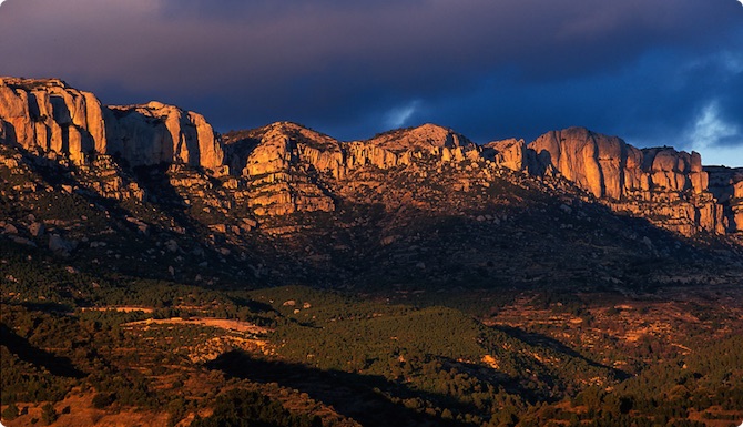
Tarragona (province), Spain
Photo: Ahatero, CC BY-SA 4.0 via Wikimedia Commons
Serra de Montsant Natural Park is in Tarragona province. The unique landscape of this park, characterized by the footprint of human activity and a steep orography of cliffs, ravines and gorges, offers us a rich natural and cultural heritage linked to the religious history in the park. Montsant can be translated from Catalan as "Holy Mountain". There are over 2000 Rock climbing routes in the park and pre-park areas.
From the travel guide. Select a place for details, a map and what is nearby.
It is a 1,163-m mountain in the municipality of La Morera de Montsant, Priorat. At its summit there is a geodesic vertex.
It is a rock formation, which, as the name suggests, is a bridge carved into the rock by erosion. You can pass under it following the Camí de la Llibreria, but the best place to observe it is from los Ventadors.
A cliff in Serra de Montsant Natural Park.
Gorge opened by the Montsant River between Ulldemolins and Margalef. It is 13 km of river course with a very well-preserved riverside ecosystem. Spectacular landforms.
Elongated and very deep pools at the confluence of the Gleva stream (which falls there in the form of a waterfall) with the Montsant river. A secluded space, but of great beauty.
A small projection of the cliff with magnificent views of the Priorat region.
Lo Guixar is a 636-m mountain. This site affords excellent views of the River Montsant valley.
Cova de Santa Llúcia
It is a wide and shallow bay, used by man since ancient times, which took on a very important role during the Spanish Civil War when it became a hospital for the International Brigades who fought, in the summer of 1938, in the Battle of the Ebro.
Pantà de Margalef
This is one of the park’s most photographed and visited sites because of the many ravines that converge here.
Cartoixa d'Escaladei
The Carthusian Monastery of Santa Maria d'Escaladei was founded in the 12th century by Alfonso el Casto and was the first Carthusian monastery in the Iberian Peninsula. Around 1203, thanks to the generous donations of King Peter the Catholic, they were located in their final location, in the desert of the Vall de l'Oliver, towards the interior of the mountain range. In 1215, they received the order from the Archbishop of Tarragona to leave the monastery to preach against the Cathar heresy that was spreading throughout Catalonia and Occitania. The 14th and 15th centuries are considered the golden age of the Carthusian order and are also the period of maximum construction of new monasteries in many countries: The Carthusian Monastery of Escaladei was one of the most important monasteries in Catalonia. The extensive heritage included many territorial possessions, with direct dominion over their villas and rustic properties, livestock, censuses of all kinds and other goods. At the end of the 16th century or at the beginning of the 17th century, a time of consolidation of its temporal domains, with great influence and prestige, the Carthusian Monastery of Escaladei began a major architectural reform. By the Mendizábal Decree of Confiscation of 1835, the monks were forced to abandon the monastery, expropriated from their lands. They took everything they could, but their famous library was dispersed throughout the Spanish territory. In 1992 it opened its doors to the public.
It has its origins in the 12th century hermitage buildings. In medieval times it had an important devotion from the surrounding towns. In the past, pilgrimages and gatherings took place there at various times of the year. Numerous prayer processions are also known to have taken place asking for rain or other heavenly favors. The hermitage was built in 1161. Around 1450, a new building, the current one, was built near the cliff that marks the boundary of the municipality of Escaladei. In 1810, the French set fire to it. In 1835, it was abandoned and in ruins. At the end of the 19th century, the chapel was restored by Ramona Ballester. The gathering of the Virgin Mary takes place on August 17, a day when people from neighboring towns also come to the sanctuary. Mass is held there, which ends with the singing of traditional hymns to the Virgin Mary, and then there is a fellowship meal.
It seems that the original construction dates back to the 13th century. However, the first information corresponds to the 16th century, when the bell was blessed in 1509 and the temple was enlarged in 1571. In 1661 the hermit's house was blessed. In the meantime, the church had been endowed with altarpieces. At the end of the 18th century, coinciding with the construction of new temples in the Priorat, the hermitage was considerably expanded, probably demolishing part of the previous construction. In 1820 it was repaired again, after the French had damaged it in the French War. In 1877 the chapel was venerated, and in 1864 the steps of the presbytery were built and the altars were repaired. In 1936 the image of Saint John was protected in the Reus Museum and returned to the temple after the war. In 1977 Montserrat Domingo settled in the hermitage of Sant Joan del Codolar, and has lived there as a hermit since then.
Mas de Sant Blai
In 1170 Albert de Castellvell donated the area to Arnau de Salflores, who built a monastery in the eastern part of the town that was called "de Bonrepòs" and where several hermits from the surrounding area gathered. The Archbishop of Tarragona Ramon de Rocabertí authorised the establishment of a female community in the town in 1210, which moved to Bonrepòs in 1215 after the monks had moved to the new charterhouse of Poboleda. In 1462, the monastery was definitively abandoned due to the lack of nuns. After the dispute between Escaladei and Santes Creus in the mid-15th century, the building was granted to the Carthusian Monastery of Escaladei, which used it as a farm; The scattered goods, objects of worship and the archive were given to Santes Creus. In 1817 the Carthusians built a farmhouse on the remains of the monastery. Once it became private property, agricultural work continued until it was abandoned, apparently in the mid-20th century. Its use and ownership have since been ceded to ICONA, where it carries out reforestation work.
resting place and oratory of the Carthusian monks. The construction was promoted by the Bishop of Urgell, monk and prior of the monastery. Initially, the chapel served the purpose of serving as a rest house and oratory for Catalan prelates. In the oratory there was an image of the Pietà which was the origin of the name given to the complex. It seems that it was converted into a farm and hermitage and that with the confiscation it became private property. It has been abandoned.
At the highest point of the Serra de Sant Pau. La Figuera. No data has been found regarding the creation of the hermitage, but it seems that it should be placed around the 16th century at least. It was probably in the 18th century that it was renovated, including the decoration and interior arrangement. There was a simple wooden altar, burned in 1936 during the Spanish Civil War. The images of the Mare de Déu de la Mola and Sant Pau are venerated in the hermitage. Pilgrimages are held there on January 15, May 15 and the second Sunday of August.
The hermitage was built in the 16th century and dedicated to Saint Mark. It included the part that is today the presbytery and had an atrium, which was demolished to expand the church. It was under the care of a foreman and later a hermit. In 1873, when Maria de les Neus, wife of Alfonso de Borbón, brother of Charles VII, visited it, they wanted to honor the illustrious guests and the dedication of the image was changed, from Mare de Déu de la Foia to Mare de Déu de les Neus.
The construction seems to date from 1594, the date shown on the portal. There had been the hermit's house and a small vegetable garden. The hermitage also had a porch, which disappeared during the course of works carried out at the end of the 20th century. The hermit lived there until 1872, when he moved to the village. It had had a wooden altar with a small altarpiece and the images of Saint Roch and Saint Sebastian, all of which disappeared during the Civil War.
There is no information about the construction but, judging by the old troglodyte buildings that accompany it, its origin is indeed ancient. According to tradition, the nearby fountain was built by the monks of Escala Dei. It would not be strange if the hermitage had a similar origin, although there is no document to prove it. According to other sources, the construction of the hermitage can be dated to the 16th century.
It seems that this hermitage has its origin in a very old hermitage, from before the colonization of those lands. Until the 15th century it was under the advocation of Santa Bàrbara but it changed ownership when Fra Llorenç Julià, a hermit, had an altar dedicated to Sant Antoni built in 1559 and to do so the building was expanded. In the 16th century it was the home of the hermit Jeroni de l'Albi. It was the subject of lawsuits between the municipality and the Carthusian Monastery of Escala Dei. In 1580, the hermit's house was expanded, which was rebuilt at the end of the 19th century and around 1960 it was transformed into a summer house.
Santa Magdalena, called the Cathedral of Montsant, is a hermitage in the municipality of Ulldemolins (Priorat) protected as a cultural asset of local interest. Santa Magdalena was founded by Fra Llorenç Julià. The plans are the work of Jaume Amigó, the same architect who had built the parish church of Sant Jaume, who took it as a model. The building was built around 1579 and at the same time a house was built in the hermitage. An attempt was made to install a convent in 1579 but the town did not authorize it. Between 1587 and 1599, the chapel was abandoned by order of the archbishop, the result of disputes between the municipality and the Carthusian monastery of Escaladei for the hermitage and the surrounding lands. During this time it was very damaged. Reopened to worship, the hermitage was enriched with altarpieces during the 18th century that were destroyed in the civil war of 1936.
The church of Sant Vicenç is located in the village of Albarca, a small village located at an altitude of 815 m at the point where the Montsant and Prades mountains meet. It is a building of Romanesque origin. It is first mentioned in 1151, on the occasion of a donation made by Ramon de Cervera and his wife Ponceta to "Petro capellano de Pinós". At the beginning of the 17th century it was largely rebuilt (the date is 1612). It is the starting point of routes 9, 17, 18 (see #Hiking).
Pont de Cavaloca
The time of construction is uncertain. The bridge is part of the road from Cabassers to Vilella Baix, separated from the route of the royal road, on which the Cabassers bridge is located, so that the connection between both constructions seems remote. The road is practically abandoned, like the bridge, located in a place of great beauty.
Pont Vell
The origin of the bridge is uncertain. Some authors maintain that it is Roman, linked to possible roads that led from the Ebro to Tarraco. Others prefer to think of a medieval origin in connection with the wheat road from Aragon to Barcelona via the Ebro. The existence of stonemason marks and the good state of conservation suggest a medieval origin. Today it is still used by tractors.
Molí dels pobres
The Poor's Mill is a building in the village of Margalef (Priorat) protected as a cultural asset of local interest. The Poor's Mill was the communal mill of the residents of Margalef. This mill was dismantled after the Civil War. In 1969, the residents of Margalef repaired the Poor's Mill to use it as a cinema. The stone sinks were found at the entrance to Carrer dels Molins in the place where the cinema had been and before the Poor's Mill. They are two sinks excavated in the rock with two cavities 1.30 m in diameter and 80 cm deep. This receptacle received the oil from the cofins - flat esparto baskets where the olives were placed.
The urban core of Cornudella de Montsant was born at the end of the 12th century, around the parish church of Sant Julià. It is about where the Plaça de la Vila is now, around which some houses with pointed arcades from the medieval period are still preserved (on Carrer de la Vileta, Carrer Major, Carrer de l'Església or Carrer del Tou). The primitive population would have been surrounded by a wall, as mentioned in the late medieval documentation. The growth of the town would have been along Carrer Major and del Tou, where the road from Prades to la Morera would have passed. In these streets and in the square you will find the most significant buildings of the population, many of them with facades and decorative elements from the 17th and 18th centuries, peak moments in the growth of Cornudella. Some examples are Cal Toval, number 19 on Carrer Major, now home to the Peris - Aragonès Museum, or Ca l'Esteve or Aleu, with a facade from the 19th century (number 48).
Occupied by the Saracens until the 12th century, King Ramon Berenguer IV reconquered and Christianized it. The construction of monasteries, churches and hermitages was one of the consequences, the most important being the Carthusian Monastery of Scala Dei and the one that gave its name to the Priorat region. In 1836, the confiscation of Mendizábal brought about the end of the active life of the Carthusian monastery and its abandonment and subsequent looting. At the end of the 19th century, the phylloxera plague devastated all the vineyards and this led to a general impoverishment of the region. Its main commercial activity is viticulture, agriculture (almonds, hazelnuts, oil and olives) and tourism.
Encircled in an impregnable place above the river, it took the knights of four counts to subdue it. Its castle defended an impassable border that stretched from the Balaguer pass to Tamarit de Gaià. Conquered in 1153, after the fall of Lleida and Tortosa, it was the last stronghold of the reconquest in Catalonia. If you look at the precipice that surrounds it, you will guess why it was not conquered for three centuries and why the end was so tragic. Abdelazia, the Moorish queen, before being subjugated by the Christians, preferred to throw herself off a cliff with her horse. And the animal, in its futile resistance, left the mark of its horseshoe on the rock, forever. And with it, the last Saracen stronghold in Catalonia disappeared. Today, you can see a charming village of houses and cobbled streets and the remains of the Saracen fortress, located at the entrance to the town. At its feet, a reservoir of clean and calm waters offers the possibility of practising all kinds of water sports. The most important building in Siurana is the church, in Romanesque style, with a portal, with a figured tympanum, framed by three semicircular archivolts that rest on columns with capitals decorated with various motifs. The town is surrounded by interesting places and is a point from which you can enjoy magnificent views of the Serra de Montsant, the Gritella and the Prades Mountains. Siurana is worth highlighting as a reference and destination for climbers and hikers. Its legendary cliffs are known all over the world for carrying out these practices.
located on the slopes of the Montsant mountain range, at the confluence of the Montsant river and the Escaladei stream. The steep slope of the hill where the old town is located has forced the construction of seven- or eight-storey houses with the main entrance on the fourth or fifth floor. This fact gives the town unique and singular characteristics. The town, at 214 m above sea level, is located on top of rocks, under which the waters of the two rivers flow. It is the southern gateway to the Serra de Montsant Natural Park, and has a tourist information point as well as hiking trails that allow you to enjoy the landscape and its natural heritage.
The town is crossed by the Montsant River and the Escaladei stream, and at the confluence where they meet there is the impressive Romanesque bridge with two arches plus a third arch that was added to overcome the stream in 1886 and that follows the architectural style of the other two. Apart from the large bridge, the church of Sant Joan Baptista, from the 18th century, in Renaissance style with three naves, stands out as a monument. The most peculiar characteristic of the town is the height of its houses that face the banks of the two rivers, which can have 6 or more floors on the river side, when the same houses on the street side can only have one or two floors. Also worth noting is the Carrer que no Passa, with strong medieval reminiscences and where the original town centre is located. You pass through a porch of pointed arches and the street has no exit. In the first of the arches you can still see the holes that were used to close yourself inside the walled enclosure in case of enemy incursions. Also noteworthy is the Modernist Agricultural Union. Within its boundaries, the mill stands out, a beautiful example of neo-Arab architecture, the various fountains (fonteta, font del barrot, font del racó...) and the medieval Cavaloca bridge that crosses the ravine of the same name, on the old royal road to Cabassers.
Cabassers
Numerous pointed arches and porches have been preserved from medieval Cabacés, especially inside the houses. Next to the canal source is the hermitage of Sant Joan, in Baroque style. Within the municipality, the hermitage of La Foia, in popular Renaissance style and of great devotion, stands out. Also worth visiting is the Pont Vell, a medieval stone bridge on the outskirts of the municipality. A large part of the municipality is not suitable for cultivation, occupied by rockeries, forests and unproductive land. Agriculture is the basic activity of Cabacés. The main crops are: dry land, olive and almond trees, in addition to vineyards and hazelnuts; fruit and vegetables. The agricultural cooperative, founded in 1933, under the name of Sindicat Agrícola, produces quality wine and oil.
It is in the Montsant river valley, on top of a rock on which it is clinging. La Bisbal stands out for its natural spaces such as the Santa Llúcia cave, a large cave, inside which there is a fresh water source and a space for barbecues. During the Upper Paleolithic period it had been occupied by a human settlement. However, within its more recent history during the Civil War, it was used as a rearguard hospital for the Republican army, during the Battle of the Ebro. Of particular interest is the church of the Nativitat de la Mare de Déu, in neoclassical and baroque style. More than half of the territory is cultivated land, while the rest is mainly occupied by forest land. The olive tree clearly dominates, followed by the almond tree. Thanks to the construction of the Margalef reservoir, peach cultivation has expanded considerably.
The rugged terrain gives rise to caves, chasms and caves, which are very popular with hikers. The town has very interesting streets, of which Carrer de les Covetes is the most interesting. One whole side of the street is rock, which serves as a support for the street above. The most important building in the town is the church of Sant Miquel, a neoclassical construction from the 18th century. The hermitage of Sant Salvador also stands out, a good place to relax where you can breathe the pure air of the majestic Montsant. Another place on the outskirts of the town that you can visit is the dam, located in an area of great natural beauty.
located in the valley of the Montsant river. From a historical point of view, it is worth highlighting the presence of hermits in the Montsant mountains, a massif that owes its name to the existence of numerous hermitages that rise around it. The best known of all was probably Fra Guerau, prior of Escaladei, who retired to the hermitage of Sant Bartomeu d'Ulldemolins to do penance. Over the centuries, his memory has been mythologized, giving rise to numerous legends. One of the most exceptional places in all of Montsant is also known by its name. There you will find historical buildings such as: the church of Sant Jaume, a Renaissance-style church from the late 16th century; the organ of the church of Sant Jaume, one of the oldest in Catalonia, built in 1637; the sanctuary of the Mare de Déu del Loreto, built at the end of the 18th century, and hermitages such as that of Sant Bartomeu, Santa Magdalena and that of Sant Antoni and Santa Bàrbara.
It is located in a privileged place at the foot of Montsant, at a point where the sun and shade of the mountain meet with the last arrears of the Serra de Prades. It is, therefore, a strategic enclave that has been known since ancient times. The origin of the town is Muslim: an almshouse in the surroundings of the Siurana castle. Near the town there are vestiges of settlement from this period: the tombs excavated in the rock of the Parada de la Guineu, burials of a small medieval community. After the Christian conquest, the inhabited nucleus developed, with the castle, documented in 1182 and of which very little remains.
Climb guides. Contact via Whatsapp at: +34 644 71 35 57. Over 95 climbing sectors in Margalef area.
Parc Astronòmic Muntanyes de Prades
At night, around 23:00, the night activity takes place, which takes place on the outskirts of Prades (3 minutes walk, easily accessible from the town center along a red-lit path). It is recommended to be well-warmed, long pants and a good coat. Even in summer the temperature drops to 10-12 °C.
See hotel in Sleep section.
See hotel in Sleep section.
Coffee, bar and some food.
Luxury hotel.
Start point of routes 9, 17, 18 (see #Hiking).
There is water source: Font de la Foia.
Àrea d'acampada de Santa Magdalena
Choose an airport to see hotels, stations, taxi ranks and car rental desks around it.
Reus · International · REU
Loading places around the airport…
Articles and travel topics about Serra de Montsant Natural Park and Spain.
 Travel tips
Understand travel insurance for a Schengen visa in 2026. Learn mandatory €30,000 medical coverage, zero deductible rules, and embassy-approved policies.
7 min read


 Travel tips
Estimate your Europe trip cost for 2 weeks in 2026. Compare realistic budgets for lodging, Eurail trains, dining, and sightseeing across three styles.
8 min read
 Travel tips
Find the cheapest countries to fly to from the US and UK in 2026. Compare realistic round-trip flight deals, budget airlines, and prime booking windows.
8 min read


 Inspiration
Explore the best places to visit in November across autumn foliage, mild desert warmth, southern spring blooms, and off-peak travel bargains.
6 min read
Every section of the guide. Open one to read it in full.