//


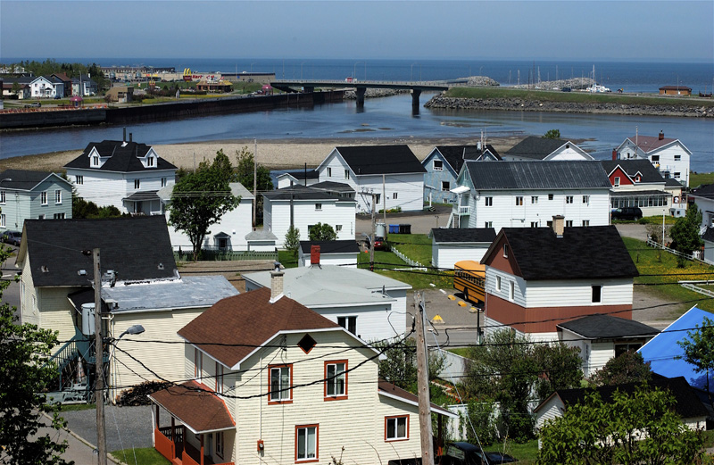
Peninsula in Quebec, Canada
Photo: Dennis G. Jarvis, CC BY-SA 2.0 via Wikimedia Commons
The Gaspé Peninsula (La Gaspésie), in southeastern Quebec, Canada, is sandwiched between the Gulf of St. Lawrence and the adjacent St. Lawrence estuary on the north, and Chaleur Bay (la Baie des Chaleurs) to the south.
The Coast (La Côte) is a region of the Gaspé Peninsula in Quebec. The Gaspé Coast comprises the south bank of the Saint Lawrence river in the southwest of the peninsula.
Upper Gaspé (La Haute-Gaspésie) is a region of the Gaspé Peninsula in Quebec. It stretches over 130 km on the southern coast of the St.
Located at its outermost extremity, where the St. Lawrence estuary meets the open ocean, Land's End (La Pointe) is where you'll find the bulk of the Gaspé Peninsula's population, as well as the most interesting attractions of the region.
Chaleur Bay (La Baie-des-Chaleurs) is a region of the Gaspé Peninsula. It has the second longest natural strip of sand in the world, making it a popular tourist destination.
The Matapédia Valley (vallée de la Matapédia) is a region of the Gaspé Peninsula in Quebec. Sometimes called "La Vallée", it is the western part of the Gaspé and the only one not to have access to the sea.
By plane
Arriving in the Gaspé Peninsula by plane usually means flying into Montreal's Pierre Elliott Trudeau International Airport (Aéroport international Pierre-Elliott-Trudeau de Montréal) (YUL), the…
By bus
The tentacles of the Orléans Express bus network extend all over Quebec, including the Gaspé Peninsula.
By boat
There are no bridge crossings of the St.
By bus
Two Orléans Express buses per day follow Route 132 eastward around either side of the peninsula, meeting up again in Gaspé.
By thumb
Hitchhiking is not the most popular way to get around the Gaspé Peninsula, but for folks who know some French, have a little bit of patience, and want to meet and socialize with locals, it can be an…
By bike
Inaugurated in 1995, the Route Verte is the largest network of bicycle routes on the American continent, with over 5,000 kilometres (3,100 miles) of on-road bike lanes and off-road trails traversing…
Choose an airport to see hotels, stations, taxi ranks and car rental desks around it.
Bonaventure · Regional · YVB
Loading places around the airport…

the largest town in the Matapédia Valley is a commercial centre surrounded by bucolic farmland quite atypical of the Gaspé Peninsula.

the beating heart of Acadian culture along Chaleur Bay, containing the massive Quebec Acadian Museum.

the gateway to Forillon National Park. Gaspé doesn't have much of interest to visitors, but its status as the Peninsula's largest town and main service centre means you'll probably pass through anyway.
a small industrial city that serves as the terminus of the easternmost ferry crossing of the St. Lawrence.

on the Gaspé's western border with the Bas-Saint-Laurent region, Mont-Joli is a regional transportation hub (with an airport, train station, and important highway crossroads) and also contains a museum dedicated to the art of weaving.

this tourist town at the eastern tip of the peninsula is most famous for its namesake, Percé Rock — an arch-shaped rock formation just off the coast swarmed constantly in the summer months by tour boats (and seabirds!)

nestled in a majestic setting on the St. Lawrence coast, this largish town is the gateway to Gaspésie National Park and offers a range of accommodation and services.
a two-for-one: the Gaspé Peninsula's iconic offshore rock formation, and a sanctuary for millions of squawking seabirds with a preserved 19th-century fishing village in the middle

hiking trails winding through a surprising diversity of landscapes, another preserved fishing village, and majestic shoreline scenery at the Gaspé's final "land's end"

Gaspésie National Park (parc national de la Gaspésie) is a Quebec provincial park in the heart of the Gaspé Peninsula. The main attraction of the park is the Chic-Choc mountains, one of Quebec's highest mountain ranges, part of the Appalachian Mountains (les Appalaches).

Miguasha National Park is a Quebec national park on the Gaspé Peninsula, Quebec. (It is not part of the Canadian national parks system.) The park is listed as a UNESCO World Heritage Site for its palaeontology.
Articles and travel topics about Gaspé Peninsula and Canada.
 Travel tips
Discover how to use AI to find cheap flights. Learn prompt strategies, smart fare engines, open-jaw routings, and error-fare booking techniques.
6 min read

The Trans-Canada Highway (TCH) is a series of provincial highways which join all ten provinces of Canada. Following 8,030 km (just under 5,000 miles) of Trans-Canada Highway across all ten provinces is one of the three…
Wikivoyage
 Itineraries
The Windsor - Québec City corridor is one of the most densely-populated regions of Canada. It extends 1150 km (710 miles) along Lake Erie, Lake Ontario and the St.
Wikivoyage
When it comes to palaeontology, Canada never falls short. With several palaeontological UNESCO World Heritage Sites, Canada has a lot to offer for any keen fossil enthusiast.
Wikivoyage
Every section of the guide. Open one to read it in full.