Money and payments
Cards and cash
ATMs can be found in most cities.

 Americas · Central AmericaUsable guide
Country in Central America
Photo: No machine-readable author provided. BetacommandBot assumed (based on copyright claims)., CC BY-SA 3.0 via Wikimedia Commons
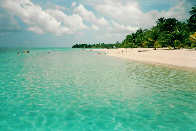
Honduras has colonial villages (Gracias, Comayagua), ancient Maya ruins (Copán), natural parks (Moskitia), and a Pacific and Caribbean coastline and the Bay Islands, with great beaches and coral reefs where snorkeling and diving are exceptional by any standard.
Answers to what travellers most often look up about Honduras.
Cards and cash
ATMs can be found in most cities.
Spanish
Spanish is the primary language spoken. English is hardly spoken outside of the biggest towns or Bay Islands.
If you have an internet capable mobile phone, you just need a local SIM card (roughly L25) and can start enjoying the prepaid access plans, which generally come in lots of an hour, a day, or a week and have a specific maximum usage.
Mobile networks
Purified water is used in big-city hotels and restaurants, but bottled water is definitely recommended for outlying areas.
Purified water is used in big-city hotels and restaurants, but bottled water is definitely recommended for outlying areas. Remember to never use the water out of the tap, unless you are certain it is safe.
Despite violence and widespread poverty, Honduran citizens are friendly people who appreciate a respectful manner and are welcoming to tourists.
Attractions, food, stays and travel essentials, with ratings, reviews, opening hours and directions.

the capital and largest city of Honduras.

port city on Caribbean coast with great beaches and daily ferries to the Bay Islands.
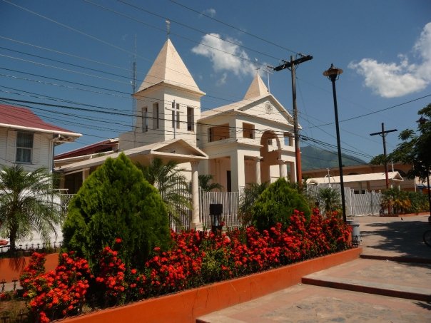
located at a strategic crossroads where major highways towards Comayagua, San Pedro Sula and Tela all converge.

the former capital of the country is today a quiet colonial town with a beautiful cathedral, notable Spanish architecture and an historic town center.

a pleasant colonial mountain town; nearby Parque Celaque is home to the highest mountain in Honduras set among wonderful cloud forests.

the main harbour town on the Caribbean coast.

located in the Sula Valley in the northwest corner of the country, this is a major transportation and economic hub.

temperate mountain city in the western part of the region, and the nearest place of any size to Copán.

One of Honduras' most exotic destinations, Leaving from San Pedro Sula by a 4x4 trail into the dense cloud forest.
Utila, Roatán, Guanaja, and the Hog Islands are a natural Caribbean paradise very popular for snorkeling and diving.

one of the most impressive ruins of the Maya civilization, known for the quality of its sculpture.

the biggest lake in Honduras which is famous for its fried fish. Nearby are two national parks that hold pristine rainforest and cloud forest as well as Honduras's first microbrewery.

the largest tropical rainforest in Central America.
Places in Honduras on the World Heritage List.
List from Wikidata (CC0). Photos from Wikimedia Commons.
The Caribbean coast with its beaches and port towns, offshore islands and a huge area of lowland jungle, including the UNESCO world-heritage site Río Plátano Biosphere Reserve.
Upland region in the middle of the country. Includes the capital city, mountain ranges, Maya ruins, and old Spanish colonial hill towns.
Small region with major Pacific Ocean ports.
Public transport and paid services in Honduras.
By boat
There is regular boat service from La Ceiba to the bay islands of Roatan and Utila.
By car
Small roads are often in poor condition and can be dangerous to drive on. During the rainy season, the condition of roads deteriorates considerably.
Apps for booking a taxi or a ride in Honduras.
Finding apps for Honduras…
Other ways to travel:By thumb
Choose an airport to see hotels, stations, taxi ranks and car rental desks around it.
Tegucigalpa · Regional · TGU
Loading places around the airport…
Calculated from climate averages: mild daytime highs and lower rainfall. It does not account for festivals, crowds or prices.
Average conditions in Tegucigalpa
| Jan | Feb | Mar | Apr | May | Jun | Jul | Aug | Sep | Oct | Nov | Dec | |
|---|---|---|---|---|---|---|---|---|---|---|---|---|
| Avg. high | 25° | 28° | 30° | 32° | 31° | 29° | 29° | 29° | 28° | 27° | 25° | 25° |
| Avg. low | 15° | 16° | 17° | 19° | 20° | 20° | 19° | 19° | 19° | 19° | 17° | 16° |
| Rainfall (mm) | 71 | 48 | 41 | 37 | 109 | 159 | 121 | 130 | 167 | 166 | 125 | 85 |
| Humidity | 83% | 76% | 69% | 64% | 70% | 79% | 80% | 79% | 82% | 86% | 87% | 86% |
Choose your passport and destination to see whether you need a visa.
Budget
$50
Per person, per day
Mid-range
$145
Per person, per day
Luxury
$365
Per person, per day
| Budget | Mid-range | Luxury | |
|---|---|---|---|
| Accommodation | $25 | $80 | $215 |
| Food and drink | $10 | $30 | $70 |
| Local transport | $5 | $15 | $30 |
| Activities | $10 | $20 | $50 |
Estimate from World Bank price levels (2025). Actual costs vary by city and season. World Bank
—
We do not label countries as safe or unsafe. Below is the official advice from two governments, with the date it was last updated. Always read the full advice before you travel.
US Department of State
Level 3 of 4Reconsider travel
Reconsider travelto Honduras due to crime and terrorism. Some areas have an increased risk. Read the entire Travel Advisory. U.S. government travel restrictions U.S. government employees working in Honduras are not allowed to travel to Gracias a Dios department due to safety risks. U.S. government employees working in Honduras are not allowed to visit adult clubs nor casinos. Extortion, overcharging, criminal surveillance, and other potential criminal activity can take place in these locations. U.S. government employees working in Honduras are not permitted to travel between cities after dark. After dark travel between Palmerola International Airport (XPL)/Soto Cano Airbase and Tegucigalpa is authorized. There is an increased risk of vehicle accidents and carjackings after dark on major highways. U.S. government employees working in Honduras are not permitted to drive through or to high crime zones unless previously approved by the Regional Security Office. Designated high crime zones in Honduras include but are not limited to: Distrito Central (Francisco Morazan): Colonia Villa Nueva, Nueva Suyapa, Flor de Campo, Los Pinos, Los Laureles, El Carrizal, Villa Cristina, La Travesia, Pueblo Nuevo, Barrio Concepción, Villa Fanca, La Laguna, San Ignacio, and Torocagua. Cortes: Lomas del Carmen, Barrio Medina, Brisas del Merendon, Col. La Pradera, Col. Rivera Hernandez, Brisas del Sauce, La Planeta, Cerrito Lindo, Col. 6 de Mayo, Cofradia, Col. Central, Col. Hector Sabillon Cruz, Barrio El Centro, Barrio Barandilla, Chamelecon, Choloma. Department of Colon Crime Violent crime…
UK Foreign, Commonwealth & Development Office
No advice against travel. Read the full advice before you go.
Before you travel No travel can be guaranteed safe. Read all the advice in this guide. You may also find it helpful to: see general advice for women travellers read our guide on disability and travel abroad see general advice for LGBT+ travellers read about safety for solo and independent travel see advice on volunteering and adventure travel abroad Travel insurance If you choose to travel, research your destinations and get appropriate travel insurance. Insurance should cover your itinerary, planned activities and expenses in an emergency. About FCDO travel advice The Foreign, Commonwealth & Development Office (FCDO) provides advice about risks of travel to help you make informed decisions. Find out more about FCDO travel advice. Get travel advice updates Sign up to get email notifications when this travel advice is updated. Follow FCDO: travel advice on X travel advice on Facebook Travel Aware on Instagram
Stories, itineraries and practical advice for travelling in Honduras.
 Nature & adventure
Honduras has 20 national parks conserving a wide range of plant and animal species across several types of ecosystems including Caribbean beaches, coastal wetlands, mountainous rainforests, and rugged volcanic peaks.
Wikivoyage
 Culture & history
The Maya civilization was one of the great Mesoamerican and Pre-Columbian civilizations. The Maya were renowned for having the most sophisticated and developed writing system in the Western Hemisphere as well as their…
Wikivoyage
 Itineraries
The Gringo trail is a term for places in Latin America visited by gringos, that is, people from North America or Europe. It is the Western Hemisphere's equivalent of tropical Asia's Banana Pancake Trail.
Wikivoyage
 Itineraries
Itineraries in North America
Wikivoyage
 Culture & history
The indigenous peoples of North America are the tribes and nations whose ancestors were already on the continent when European explorers and colonizers arrived.
Wikivoyage
 Nature & adventure
As of 2023 the UNESCO World Network of Biosphere Reserves is made up of 738 reserves in 134 countries of which 22 are transboundary.
Wikivoyage
Every section of the guide. Open one to read it in full.


