Money and payments
Cards and cash
ATMs can be found in the major towns but do not expect to find them in every tourist spot.


 Americas · Central AmericaUsable guide
Country in Central America
Photo: Jacques Descloitres, MODIS Land Rapid Response Team, NASA/GSFC, Public domain via Wikimedia Commons
Guatemala has a rich and distinctive culture from the extended mixing of Spanish settlers and the Maya people who are native to Central America. This diverse history and the natural beauty of the land have created a destination rich in interesting and scenic sites. Guatemala is very tough land—you can experience dense jungles, mountainous terrain with volcanic activity, other seismic activity (earthquakes, mudslides), and hurricanes.
Answers to what travellers most often look up about Guatemala.
Cards and cash
ATMs can be found in the major towns but do not expect to find them in every tourist spot.
Spanish
Spanish is the official language of Guatemala and is spoken by almost everyone in the main tourist destinations.
Use the local SIM cards (roughly Q25) and the prepaid access plans, which generally come in lots of data and include a number of minutes for domestic (and US) calls.
Mobile networks
 Tigo Guatemala
Drink only purified water (Agua Pura Salvavidas is recommended by most hospitals and hotels).
Much of what is considered good manners in Latin and South America is applicable to Guatemala. The various tips found in the respect section of the Latin America article will come in handy when you visit the country.
Covered in the guide
Attractions, food, stays and travel essentials, with ratings, reviews, opening hours and directions.

Guatemala City is the capital of Guatemala, a country in Central America. With a population of around 3 million people, Guatemala City is the largest and most modern city in Guatemala.

La Antigua Guatemala is a UNESCO World Heritage Site, and is perhaps Guatemala's most popular tourist destination. It was the colonial Spanish capital of Central America.
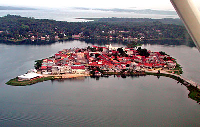
Flores is a town in Petén, Guatemala. The town proper is an island on Lago Petén Itzá (la isla), connected to land by a causeway (el puente), on the other side of which lie the twin towns Santa Elena and San Benito.

Melchor de Mencos is in Guatemala on the border with Belize and is usually a place that most travelers merely pass through, but it does have some stelae and zoomorphs in a square not far away. From the border, go to the first main road to the right.

Panajachel is in the Western Highlands of Guatemala. Panajachel, or Pana as it is widely known is a small town on the North shore of Lake Atitlán.

Puerto Barrios is a seaport and the capital of the department of Izabal on the Caribbean Coast of Guatemala. Its population in 2018 was just over 100,000 people.

Puerto San José is a city of 24,000 people (2018) in the Pacific Lowlands region of Guatemala.

Quetzaltenango, also known as Xela (pronounced SHAY-la) or Xelaju, is the second largest city in Guatemala. There are a number of attractions in town, and it's also a good base for exploring Guatemala's Western Highlands ("Los Altos").

Aguateca is in the Peten department of the Northern Lowlands of Guatemala.

El Mirador is a large site of Mayan ruins in the Petén department of Guatemala.

The Central Highlands is the region around Guatemala City, stretching northwards to the Northern Lowlands in Guatemala.

Lago de Atitlán (English: Lake Atitlán) is a beautiful volcanic lake in the Western Highlands of Guatemala, renowned as one of the most beautiful lakes in the world, and is one of Guatemala's most important national and international tourist attractions. It is ringed by small towns, many of which are favourites among backpackers.

Monterrico is the most popular beach in Guatemala and also the closest to Guatemala City and Antigua. The beaches are full of interesting but awkward steep angles due to the strength of the pounding surf.

El Remate is a small, relaxed little village on the east side of Lago Petén Itza. Some travelers looking for peace and quiet opt to stay here rather than Flores as a base for exploring the lake and the region.

Rio Dulce (also called Fronteras) is a coastal river town in eastern Guatemala. It is also the name of a national park that spans an area of about 130 square kilometers along the Rio Dulce and its lake.

Semuc Champey is a set of crystalline pools over the Río Cahabón in Alta Verapaz, Guatemala. It consists of a natural 300 m limestone bridge, under which passes the Cahabón River.
Places in Guatemala on the World Heritage List.

Quiriguá
Listed 1981

Takalik Abaj
Listed 2023

Tikal National Park
Listed 1979

College of the Company of Jesus
Antigua Guatemala
Listed 1979
List from Wikidata (CC0). Photos from Wikimedia Commons.
Guatemala City and the popular tourist destination Antigua Guatemala are located in this region. It is home to at least one active volcano.
By far the most beautiful part of Guatemala, this region includes many indigenous Mayan villages. Lake Atitlán is also in this region, along with at least 2 active volcanoes.
A dry region on the routes to Honduras and El Salvador, with a mostly Hispanic population, and dedicated to cattle ranching.
This coast is home to many beaches.
This region has very dense jungled rainforest, and some amazing Mayan ruins, including Tikal.
This consists of the rolling foothills of the Sierra Madre, extending across the wide Pacific plain to beautiful beaches.
Public transport and paid services in Guatemala.
By plane
Regular domestic flights only operate between Guatemala City GUA and Flores FRS on Transportes Aéreos Guatemaltecos (TAG) and Avianca (formerly Taca Regional and Aviateca).
By car
Road safety is poor, especially on highways. Roads are in relatively poor condition, except for main roads. During the rainy season, the condition of roads deteriorates considerably.
Apps for booking a taxi or a ride in Guatemala.
Finding apps for Guatemala…
Operators checked against their official websites in October 2026; services that have stopped running are not listed. Logos and Wikipedia links: Wikidata (CC0)
Choose an airport to see hotels, stations, taxi ranks and car rental desks around it.
Guatemala City · International · GUA
Loading places around the airport…
Calculated from climate averages: mild daytime highs and lower rainfall. It does not account for festivals, crowds or prices.
Average conditions in Guatemala City
| Jan | Feb | Mar | Apr | May | Jun | Jul | Aug | Sep | Oct | Nov | Dec | |
|---|---|---|---|---|---|---|---|---|---|---|---|---|
| Avg. high | 26° | 28° | 30° | 30° | 28° | 25° | 26° | 25° | 25° | 24° | 24° | 24° |
| Avg. low | 13° | 14° | 15° | 17° | 18° | 18° | 17° | 17° | 17° | 16° | 15° | 13° |
| Rainfall (mm) | 5 | 7 | 12 | 41 | 163 | 225 | 172 | 223 | 243 | 191 | 43 | 8 |
| Humidity | 73% | 68% | 63% | 66% | 76% | 84% | 83% | 85% | 87% | 87% | 83% | 79% |
Choose your passport and destination to see whether you need a visa.
Budget
$45
Per person, per day
Mid-range
$130
Per person, per day
Luxury
$345
Per person, per day
| Budget | Mid-range | Luxury | |
|---|---|---|---|
| Accommodation | $25 | $75 | $200 |
| Food and drink | $10 | $25 | $65 |
| Local transport | $5 | $10 | $30 |
| Activities | $5 | $20 | $50 |
Estimate from World Bank price levels (2025). Actual costs vary by city and season. World Bank
—
We do not label countries as safe or unsafe. Below is the official advice from two governments, with the date it was last updated. Always read the full advice before you travel.
US Department of State
Level 3 of 4Reconsider travel
Reconsider travelto Guatemala due to crime and terrorism. Some areas have higher risks. Please read the full Travel Advisory. Some areas of Guatemala have higher levels of gang-related violence. Crimes include robbery, carjacking, drug trafficking, assaults, and murders. Local law enforcement often struggles to address serious crimes. This leads to low arrest and conviction rates. Tourists can become victims of opportunistic crimes such as scams and extortion. There is risk of terrorist attacks and other terrorist activities from cartels, gangs, and criminal organizations in San Marcos Department, Huehuetenango Department, Zone 18 in Guatemala City, and the city of Villa Nueva. Visit the U.S. Department of State’s Country Reports on Terrorism to learn more. Tourist Assistance Program Guatemala offers the Tourist Assistance Program (ASISTUR) to protect tourists. ASISTUR partners with tourist police (DISETUR) in popular areas like Antigua, Lake Atitlán, Tikal, Quetzaltenango, Puerto Barrios, and Coban. Dial 1500 or +502-2290-2810 anytime from a Guatemalan phone number. You can also message them on WhatsApp at +502-5188-1819. Their emergency call center operates in Spanish and English. You can request a security escort if your group feels unsafe. U.S. government employee travel restrictions U.S. government employees and their families are not permitted to travel to the San Marcos Department, Huehuetenango Department, Zone 18 in Guatemala City, and Villa Nueva due to safety risks. U. S. government employees can travel to other parts of Guatemala and visit popular destinations…
UK Foreign, Commonwealth & Development Office
Advises against all but essential travel to parts of the country
Your travel insurance could be invalidated if you travel against advice from the Foreign, Commonwealth & Development Office (FCDO). Areas where FCDO advises against all but essential travel FCDO advises against all but essential travel to: within 5km of the Mexican border from the Pacific Coast up to and including the Gracias a Dios crossing to the towns of Santa Ana Huista, San Antonio Huista and La Democracia in the department of Huehuetenango Find out more about why FCDO advises against travel to these areas. Before you travel No travel can be guaranteed safe. Read all the advice in this guide. You may also find it helpful to: see general advice for women travellers read our guide on disability and travel abroad see general advice for LGBT+ travellers read about safety for solo and independent travel see advice on volunteering and adventure travel abroad Travel insurance If you choose to travel, research your destinations and get appropriate travel insurance. Insurance should cover your itinerary, planned activities and expenses in an emergency. About FCDO travel advice The Foreign, Commonwealth & Development Office (FCDO) provides advice about risks of travel to help you make informed decisions. Find out more about FCDO travel advice. Get travel advice updates Sign up to get email notifications when this travel advice is updated. Follow FCDO: travel advice on X travel advice on Facebook Travel Aware on Instagram
Stories, itineraries and practical advice for travelling in Guatemala.
 Nature & adventure
Guatemala has more than 30 national parks preserving many types of ecosystems including dense lowland tropical jungle, mountainous forests, volcanic peaks, and the subterranean wonders of natural caverns.
Wikivoyage
 Culture & history
The indigenous peoples of North America are the tribes and nations whose ancestors were already on the continent when European explorers and colonizers arrived.
Wikivoyage
 Culture & history
The Maya civilization was one of the great Mesoamerican and Pre-Columbian civilizations. The Maya were renowned for having the most sophisticated and developed writing system in the Western Hemisphere as well as their…
Wikivoyage
 Nature & adventure
Volcanoes come in many shapes and sizes, and their eruptions vary hugely in both frequency and intensity. Many volcanoes are tourist attractions and are worth a visit provided you take due care, in particular keeping a…
Wikivoyage
 Travel tips
Chicken Buses can be primarily found in Central American countries — Guatemala, El Salvador, Honduras, Nicaragua, Costa Rica and Panama.
Wikivoyage
 Itineraries
Cenotes of the Yucatán is a route through the Yucatán Peninsula of Mexico. It follows a network of secondary roads through the interior of the peninsula which the Mexican government has dubbed La Ruta de los Cenotes…
Wikivoyage
Every section of the guide. Open one to read it in full.


