//

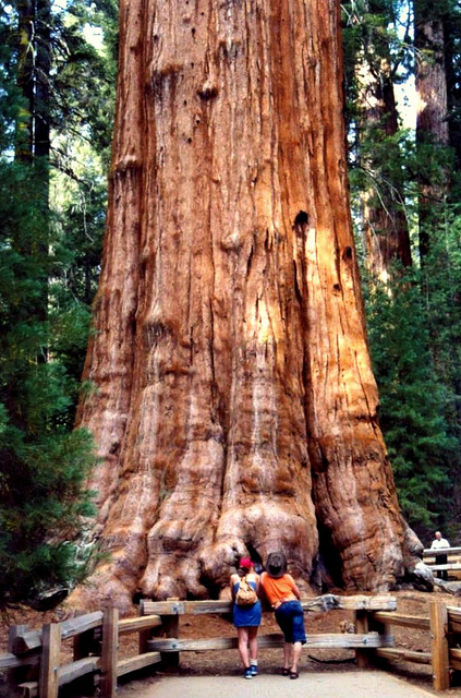
Adjacent national parks in California
Photo: Smithfl, CC BY-SA 3.0 via Wikimedia Commons
Sequoia and Kings Canyon National Parks are two national parks in the Sierra Nevada region of California. These two adjacent parks offer a variety of mountain and forest scenery.
From the travel guide. Select a place for details, a map and what is nearby.
This visitor center is next to the South Fork of the Kings River in mixed conifer forest at an elevation of 4,600 feet (1,400 m). Learn about the natural and cultural history of the Cedar Grove area. A bookstore offers books, maps, and educational items. Other services include accessible restrooms and a pay phone.
In the foothills oaks and chaparral; elevation 1,500 feet (457 m). Focus here is on the Sierran foothills, the most biologically diverse area of these parks.
Housed in a historic market building in the Giant Forest sequoia grove at 6,500 feet (1,980 m) elevation. Learn about sequoia groves and fire. Get park information and browse books in a small bookstore.
In the mixed-conifer forest; elevation 7,600 feet (2,320 m).This small station houses some exhibits on Mineral King's human and natural history. Books, maps, and educational items for sale. Bear canisters available. Pay phone in nearby campground. First aid. Local wilderness permits.
Proclaimed as the Nation's Christmas tree.
You can walk inside this fallen sequoia tree which is just next to General Grants tree.
a collection of groves at the center of Sequoia a few miles south of the main Visitor Center, including the General Sherman Tree, the world's largest (by volume and weight) tree. The area centers around a museum, and the grove can be seen along a 1-2 mile looping trail. The parking area is 0.4 miles uphill from the grove, so those who may not be able to easily walk back up the trail (remember that the elevation is 7000 feet) may want to arrange for a pickup from the main park road.
A 3-mile (5 km) road leaving General's Highway at the Giant Forest Museum. Leads to several features at the south of the Giant Forest. Note that this road is not recommended for trailers or RVs.
A granite dome you can climb to the top of via a steep 1/4-mile (0.4-km) staircase to the summit (300-foot, 91-m elevation gain). The top provides spectacular views of Sequoia's mountains and the Great Western Divide. Note that this is not for those afraid of heights as the staircase is very narrow with steep drop-offs.
A fallen sequoia in which you can drive your car through the tree. A bypass is available for tall vehicles. It is at an extremely short drive from Moro Rock and shouldn't be missed if visiting Moro Rock.
A giant sequoia log formerly available for vehicles to drive onto, for a photo opportunity. The natural process of decay has put an end to the practice as the log can no longer safely support the weight of a vehicle.
A High-Sierra meadow awash with wildflowers in the summer.
the main area of Kings Canyon, is about 45 minutes northeast of Grants Grove. The deep canyon offers impressive mountain scenery, a waterfall, and broad meadows.
Cut by the Roaring River down a narrow granite chute. A trail connects the falls viewing area to Zumwalt Meadow 1.8 miles away.
A large meadow with a two mile loop trail.
Literally the end of highway 180. A parking area provides access to many backcountry trails. Muir's Rock is located near the parking area and provides impressive views of the King's River surrounded by high peaks.
A secluded, narrow, alpine valley accessible by car. Two campgrounds in the area, from which it's possible to make day hikes to lakes and mountain passes with splendid views.
Longer day hike to a rugged peak with excellent views. This is the only day hike on the developed west side that affords a view of Mount Whitney, though still much inferior to views from the Owens Valley. The most practical trailhead is Wolverton, just south of Lodgepole.
Near the Big Stump Entrance in Kings Canyon, this 2-mile loop trail explores a grove that was heavily logged in the late 19th century.
A large cave filled with various water-sculpted features. The temperature in the cave is 50°F (10°C) so dress warmly. No strollers, tripods, or baby backpacks are allowed in the cave and it is not wheelchair accessible. Tickets for a tour must be bought at either the Lodgepole or Foothills visitor center, neither of which is located near the cave.
Easy day hike from Grant Grove. Especially attractive in the winter when the road to Cedar Grove is closed, as it affords a similar view.
A good day hike when in the canyon.
Easier day hike to a large waterfall, near Lodgepole. 3.5 miles round-trip.
21 sites. The campground is situated along the East Fork of the Kaweah River in a once logged sequoia grove. There are limited services at Silver City Resort, 1.7 miles (3 km) east of the campground. More extensive services can be found in the town of Three Rivers, 23 miles (37 km) west of Atwell Mill Campground.
110 sites. All sites are first-come, first-served. Azalea campground is located 3.5 miles (5.6 km) from Kings Canyon Park entrance in the Grant Grove area. The campground is situated under open stands of evergreen trees. Services can be found in Grant Grove Village.
28 sites. The campground is situated on the Middle Fork of the Kaweah River under an open stand of oaks. The closest services can be found in the town of Three Rivers just west of the Ash Mountain Entrance Station.
16 sites. Canyon View campground is located on Highway 180, 0.25 miles from Cedar Grove Village. The campground is situated on the floor of the canyon along the South Fork of the Kings River. This campground is for medium and large groups. Services can be found in Cedar Grove Village.
40 sites. All sites are first-come, first-served. The campground is located near the Mineral King Visitor Center amid aspen trees and conifers. There are limited services at Silver City Resort, 2.5 miles (4 km) west of the campground. More extensive services can be found in the town of Three Rivers, 27 miles (44 km) west of Cold Springs Campground.
50 sites, 14 group sites. Group sites can be reserved in advance, individual sites are first-come, first-served. The campground is situated under open stands of evergreen trees. Services can be found in Grant Grove Village.
222 sites, 4 group sites. The campground is located under open stands of evergreen trees. Services can be found at Wuksachi Lodge (8 mi, 13 km), Stony Creek Lodge (5.5 mi, 9 km), or Lodgepole Village (9 mi, 14.5 km).
204 sites. This large campground is located in fir forest along the Marble Fork of the Kaweah River. The closest services can be found 0.25 miles away in Lodgepole Village.
121 sites. The campground is situated on the floor of the canyon along the South Fork of the Kings River. Of the Cedar Grove campgrounds, Moraine offers the best views of Kings Canyon's steep granite cliffs. Services can be found in Cedar Grove Village.
42 sites. Situated along the Middle Fork of the Kaweah River under an open stand of oaks, the campground is hot in the summer and usually snow-free in the winter. The closest services can be found in the town of Three Rivers just west of the Ash Mountain Entrance Station.
82 sites. The campground is situated in the canyon along the South Fork of the Kings River under open stands of evergreen trees. Services can be found in Cedar Grove Village.
111 sites. Sheep Creek campground is situated on the floor of the canyon beside the confluence of the South Fork of the Kings River and Sheep Creek. Services can be found in Cedar Grove Village.
10 sites. All sites are first-come, first-served. This small, primitive campground is situated in a remote area of the foothills on the South Fork of the Kaweah River at the transition from oaks to evergreens. Two trails leave from a trailhead nearby: the Garfield Grove and Ladybug trails. Other park features are over an hour's drive away. The dirt portion of the road is rough, and cars with low clearance are not recommended.
159 sites, 2 group sites. Sunset Campground is located in an open stand of evergreens. Services can be found in Grant Grove Village.
By plane
The closest commercial airports are Fresno Airport and Bakersfield. The nearest international airport is Los Angeles International Airport (LAX). All three offer car rentals.
By train
Fresno and Hanford are the closest cities with an Amtrak station, both served by the Gold Runner Oakland/Sacramento - Bakersfield route.
By bus
Greyhound stops in Fresno and Visalia. From Visalia, a $20 round trip shuttle goes to Sequoia National Park.
By car
The parks are on the western slope of the Sierra Nevada, and can only be entered by car from the west. The two main entrances are:
By foot
The Eastern parts of the park are accessible from trailheads off Highway 395.
By free in-park shuttle
Sequoia National Park provides a free in-park shuttle. There is no public transportation in Kings Canyon National Park.
Choose an airport to see hotels, stations, taxi ranks and car rental desks around it.
Fresno · International · FAT
Loading places around the airport…
Articles and travel topics about Sequoia and Kings Canyon National Parks and United States.
 Travel tips
Find the cheapest countries to fly to from the US and UK in 2026. Compare realistic round-trip flight deals, budget airlines, and prime booking windows.
8 min read


 Travel tips
Find the best time to visit Hawaii in 2026. Compare whale seasons, big-wave surf, dry shoulder months, hotel rates, and island microclimates.
8 min read
 Inspiration
Discover the best places to visit in April. Compare Dutch tulip fields, Thailand's Songkran water festival, Roman spring gardens, and cherry blossoms.
6 min read


 Travel tips
A practical guide to travelling with medication and refrigerated drugs like insulin and GLP-1s. Learn airline rules, customs papers, and cooling tips.
7 min read


Every section of the guide. Open one to read it in full.