//

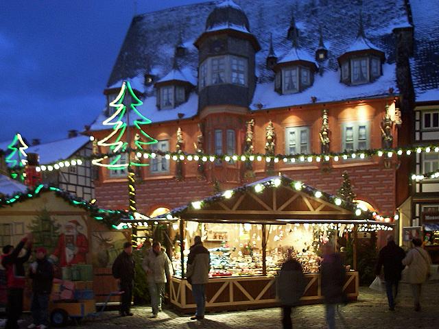
Low mountain range in northern Germany
Photo: (WT-en) HaJo at English Wikivoyage, Public domain via Wikimedia Commons
The Harz is a low mountain range in the Central Uplands of Germany, famous for its historic silver mines that brought prosperity to the region and to the Electorate of Hanover. It lies between the river Elbe and Weser in the states of Lower Saxony, Saxony-Anhalt and, to a small extent, Thuringia. The range runs for 100 km from northwest to southeast and is 30 km wide. The terraced plateaus are made of limestone, sandstone, and slate and have been cut by many narrow, deep valleys. The two highest peaks in the area are the legendary and mysterious Brocken (1,141 m or 3,743 feet high), just higher than Snowdon , and the Wurmberg (971 m or 3,186 feet high), both of which are made of granite. The higher, northwestern area is known as the Upper Harz (Oberharz) and the lower, southeastern area is the Lower Harz (Unterharz). The highest mountains - around the Brocken - are sometimes called the High Harz (Hochharz).
From the travel guide. Select a place for details, a map and what is nearby.
Part of the Bode Valley (Bodetal) between Treseburg and Thale. The gorge originates on the east side of the Brocken and runs from a depth of 280 m at Thale up to 140 m at Tresburg. The gorge is a nature reserve in its own right covering an area of just under 500 hectares and is only accessible on foot. Other forms of transport are banned, including rafting, and walking off route is forbidden, but an accessible path wends its entire length, 10 km (6 mi). There are a number of interesting places, along the route, many linked to old German myths and traditions and there are 4 stations that count towards the Harzer Wandernadel. The Bode Gorge is one of the most popular walking destinations in the Harz Mountains.
The highest mountain in the Harz range and the highest mountain in Northern Germany. The quickest way to get to its 1,141 m summit is by the Harz Narrow Gauge Train (Brockenbahn). It has a long history. It was built at the end of the 19th century in order to connect the Harz's mineral resources, forestry, and small industries to the rest of an economically rising Germany, as well as to promote the beginnings of tourism. Since 1899 it has been possible for passengers to travel up to the summit. Altogether the narrow gauge railway net is over 130 km long.
The tradition of radio and TV engineering on the Brocken dates back to the beginning of TV broadcast. It was determined in 1929 during the first wireless television broadcasting, that the short wave used was not suitable for television. Also, very high locations were required for its transmitters to transmit the very high frequencies required for TV to succeed. In 1934, the post office was given responsibility for building a mobile transmitter. In 1935 the first public picture transmission took place. In 1936, there were live transmissions of the Olympic games in Berlin. From 1936 to 1937 a 52-m-high television station and hotel with 16 floors was built. With the installation of the antenna system in 1938 the television station became operational. With the beginning of World War II, television transmissions stopped. Radio broadcasts on up to 40 transmitters carried on. In April 1945 an air raid by the Americans destroyed the hotel. The transmitter however was spared, to be used by the occupying forces. In 1947 allied troops pulled out toward the west. To justify the Americans having their part of Berlin, Saxony-Anhalt was handed to the Soviets. The Americans left in a state of chaos and the station was a gutted ruin. In 1948 the TV tower was shortened by around seven floors and a flat roof was added. From 1973 to 1976 the new landmark 152 m high metal end transmitter masts were built to enable the transmission of the East German TV channel "DDR 2". Now there is a museum and restaurant, a more modern hotel, and various cafes. The views from the summit are breathtaking and with the correct equipment and right weather conditions, some towns and reference points can be seen up to 80 km away.
A romantic valley with magnificent rocky scenery and the Romkerhall Falls, it is considered by nature and trekking enthusiasts as the most beautiful valley in the Harz Mountains. The River Oker runs through this stunning valley, starting in the middle of the Harz National Park, at over 900 m elevation and runs in a general northerly direction, for 105 km until it joins with the River Aller at Müden/Örtze near Celle. Historically, the River Oker has formed an important political boundary. It flows through deep rocky ravines and over waterfalls. This is the Oker Valley at its best. Since 1956 the Oker Valley Dam (Okertalsperre) has stopped the river from overflowing. This was an issue in the late-1940s when the towns of Brunswick (Braunschweig) and Wolfenbüttel were flooded. The dam stopped this happening again. However the small hamlet of Schulenburg was destined to be inundated by the dam's construction. So the town was removed in 1954 and rebuilt above the dam. The dam provides drinking water for towns as far away as Hildesheim and Hanover, as well as being a very efficient hydro-electric site that provides over 4 megawatts of power to the surrounding area.
Part of the Upper Harz Brocken community, a village of nearly 1,000 inhabitants. The village is near the Bode River, and in the Harz Mountains is best known as being an important railway station on the Rübeland Railway, which was built from 1880-1886 and previously known as the Harz Railway. The Rübeland Railway operates special festive train services at different times of the year between Blankenburg and Rübeland using old steam locomotives. The journeys take about 45 min each way, and there is the attraction during Advent of visiting the Christmas market in Rübeland. Amongst the other attractions nearby is the famous viewing point on the Schornsteinberg ("Chimney Hill") which is also a checkpoint on the Harzer Wandernadel hiking network.
The valley is dominated by the river Selke with its source in the Lower Harz and a tributary of the river Bode falling over an overall height of 340 m. The river is 64 km in length of which 30 km flow through the mountains of the Harz and the last 34 km through the agricultural land of the Harz approaches. The river itself was often the cause of sudden floods with water bursting its banks, and as a result a number of dams were planned along its route. The most recent project is a storm water embankment near Meisdorf planned to be 12 to 18 m high. A local protest movement has claimed that the embankment would ruin the landscape, and further arguments have been raised by inhabitants in villages up stream that not enough flood protection is available and so plans are in progress for dams at Straßbeg to protect the current storm water dam at Uhlenbach.
A striking medieval castle, high on a ridge above the Selke Valley, was built between 1120 and 1180 and since then has been used in a number of different ways. Because of its position it was never captured. Today the castle is a museum and one of the most popular places to visit in the Harz Mountains. The museum is on the so called "Romantic Road" and contains amongst other things a falconry, and a restaurant that offers a special 'Knights' Menu'. Since 2006 a European-wide singing competition has been held in the castle known as the 'Minneturnier', which refers to a singing contest in the Middle Ages, and today famous singers from Austria, Italy, France, Switzerland and Germany take part. The castle is number 200 on the Harzer Wandernadel hiking network.
Among the attractions of the Selke Valley is the Selke Valley Railway or Selketalbahn. This is a metre gauge railway that passes through Quedlinburg, Gernrode, Alexisbad and Harzgerode, with branch lines from Alexisbad to Stiege to Hasselfelde, and from Stiege to the Eisfelde Talmühle, much of this track being relaid in 2006 to link to the Harz Narrow Gauge Railway. The railway itself has become a delicatessen for railway aficionados as it travels through the most dramatic parts of the central Harz using small steam engines of which only 17 were built, and the route traverses the steepest grade in the Harz railway system of 4%. At Stieg station there is a unique terminal loop known as a balloon loop which allows heavier trains destined for Silberhütte to turn without reversing.
The Harz is a hiker's and walker's paradise and is criss-crossed by trails of every conceivable length and difficulty. Many of the longer trails are named: the Goethe Way (Goetheweg), the Kings and Emperors' Way, the Inner German Border Way, and the Harz Witches' Path (Harzer Hexenstieg) to name a few. In order to encourage fitness and tourism, the Harzer Wandernadel was founded a few years ago. They established a network of checkpoints and a badge system based on the number of checkpoints visited. Thousands of hikers, young and old, have participated in the scheme. This is a great way to explore the Harz as the checkpoints are sited at places of interest: lofty crags, medieval castles, museums, lakes, view points, and hilltops. The pass books (€2) and map sets (€7.50) may be purchased in most information and tourist offices in the region as well as participating restaurants and museums or online. Contact details for the Harzer Wandernadel are:
The Harz is home to Germany's first official naturist hiking trail, the Harzer Naturistenstieg. Consisting of a circuit of about 13 km from the dam in Wippertal and clearly signposted as an area where public nudity may be encountered, it offers naturists a space where they can legally hike naked through the forests.
By bus
Flixbus is by far the biggest name in the game.
By car
The A38 runs south of the Harz from Halle to Göttingen and the A395 connects Goslar and Bad Harzburg in the northwest with Brunswick (Braunschweig).
The best-known mode of transport is the historic narrow-gauge steam railway network operated by the Harz Narrow Gauge Railways (Harzer Schmalspurbahnen) or HSB.
Read in the guideChoose an airport to see hotels, stations, taxi ranks and car rental desks around it.
Erfurt · International · ERF
Loading places around the airport…

charming spa town, ancient cable cars, and a base for walks in the surrounding hills

the main ski resort and cable car to Lower Saxony's highest peak, the Wurmberg

a resort in the Harz. Its manufactures include textiles and wood products. The town was once a centre for the mining of copper, zinc, and lead

former Free Imperial Town with more than 1,000 years of history
the highest settlement in Lower Saxony and starting point for numerous walks

Herzberg am Harz is a town in southern Niedersachsen, Germany, on the southwestern rim of the Harz mountain range and the Harz National Park. Its 16th-century castle houses a small cultural centre with a restaurant, a museum and the great hall, which is used for various cultural events.
quaint former East German town and home to an imposing castle

playing a piece of music that's scheduled to last for 639 years

historic town on the River Ilse, north of Wernigerode

its beautiful town centre is a UNESCO World Heritage Site

historic border village and starting point for walks up the Brocken

a health resort in the state of Saxony-Anhalt

old mining town and former summer resort for Berliners; gateway to the Bode Gorge

known for its impressive Romanesque castle and its timber-framed houses that have been largely preserved in their original styles
Articles and travel topics about Harz and Germany.
 Travel tips
Understand travel insurance for a Schengen visa in 2026. Learn mandatory €30,000 medical coverage, zero deductible rules, and embassy-approved policies.
7 min read

 Travel tips
Estimate your Europe trip cost for 2 weeks in 2026. Compare realistic budgets for lodging, Eurail trains, dining, and sightseeing across three styles.
8 min read
 Travel tips
Plan your trip with our Oktoberfest 2027 guide. Learn how to reserve beer tent tables, understand Munich hotel booking windows, and budget daily costs.
8 min read
 Inspiration
Explore the best castle and gothic hotel stays in Europe. Discover historic fortresses, medieval estates, luxury châteaux, and Spanish parador hotels.
6 min read
Every section of the guide. Open one to read it in full.