//

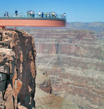
Photo: Complexsimplellc at English Wikipedia, CC BY 2.5 via Wikimedia Commons
The Skywalk is a 10 ft wide glass bottomed walkway that extends 70 ft over the canyon rim, allowing visitors to look 4,000 ft down to the canyon bottom. This attraction is what attracts the majority of visitors to this area of the canyon, but be aware that it is not a part of the national park and is pricier than most visitors expect. No strollers or personal items may be taken onto the Skywalk including cameras; professional photos can be purchased for $30 per photograph, or $100 for all photographs taken.
The Grand Canyon Skywalk is a horseshoe-shaped cantilever bridge with a glass walkway at Eagle Point in Arizona near the Colorado River, on the edge of a side canyon in the Grand Canyon West area of the main canyon. It opened as a tourist attraction in 2007, located outside the boundaries of the Grand Canyon National Park.
© OpenStreetMap contributors
This is a steep, marginally maintained, rocky trail that descends from the South Rim to the river, passing fossilized reptile tracks and abandoned camps from the early 1900s along the way. The trailhead is just beyond Hermit's Rest and is accessible via shuttle bus. Shade is scarce during the summer. Water is sometimes available at Santa Maria Spring, and is always available in Hermit Creek; both sources must be treated. This trail also provides access to Dripping Springs. Round-trip distances to waypoints are: Dripping Springs Trail junction, at 3.2 mi with 1400 ft of elevation change; Hermit Camp, at 14.0 mi with 3840 ft of elevation change; and Colorado River, at 17.0 mi with 4240 ft of elevation change.
At the West end of Hermit Road, this gift shop and snack bar was designed by Mary Colter (the same person responsible for the Watchtower at Desert View) to resemble a Hermit's abode, and fit in harmoniously with the landscape. Constructed of a mix of stone and wood.
The park's most popular trail is the Bright Angel trail which starts near the Bright Angel Lodge. This trail traverses a seemingly unending series of switchbacks down the canyon wall before leveling out somewhat around the oasis of Indian Gardens. During the summer months water is available at: the Mile-and-a-Half Resthouse 1.5 mi, the Three-Mile Resthouse 3.0 mi and Indian Gardens 4.5 mi. However, check to ensure that the water is functioning before departing, as water main breaks are common. Most hikers will traverse only a portion of this trail, and the park recommends that day hikers never attempt to go further than Indian Gardens. Winter hikers should note that the top 2 mi of this trail are likely to be icy. Round-trip distances to waypoints are: Mile-and-a-Half Resthouse, at 3.0 mi with 1131 ft of elevation change; Three-mile Resthouse, at 6.0 mi with 2112 ft of elevation change; Indian Garden, at 9.8 mi with 3060 ft of elevation change; River Resthouse, at 16.2 mi with 4380 ft of elevation change; and Bright Angel Campground, at 19.2 mi with 4380 ft of elevation change.
Good views, the trailhead of the Bright Angel Trail, historic buildings, and massive crowds.
A paved, generally flat trail along the South Rim. Viewpoints along this path have views just as good as Mather Point but with way less people. Some points along the trail go near parking lots and shuttle bus stops, so there are lots of options to do just a section of the route, which is a good choice for visitors who want something easier than the more serious trails listed below. A section of the Rim Trail includes the 2.83 mi Trail of Time, which takes you through the past 2 billion years of geologic history by way of interpretive signs and rock samples.
Slightly steeper than the Bright Angel trail, this trail starts from Yaki Point and follows a ridgeline into the canyon. Because the trail follows a ridge the views are spectacular and wide-open, but the amazing scenery comes at a cost: there is almost no shade to protect hikers from the sun, and the lack of natural water sources means that there is less plant and animal life. Hikers should be aware that there is no water available along this trail and prepare for brutal conditions – summer hikes can be particularly dangerous. Round-trip distances to waypoints are: Cedar Ridge, at 3.0 mi with 1140 ft of elevation change; Skeleton Point, at 6.0 mi with 2040 ft of elevation change; the Tipoff, at 8.8 mi with 3260 ft of elevation change; and Bright Angel Campground, at 14.0 mi with 4780 ft of elevation change.