//


The West Bank is an area located in the Middle East between Israel and Jordan, to the north of the Dead Sea. It forms the larger half of the semi-autonomous Palestinian Territories, the smaller half being the Gaza Strip. De facto control on the ground tends to be Israeli, Palestinian (Fatah since the Hamas takeover of Gaza) or some degree of joint sovereignty. Be prepared for that to affect your travels and to come upon checkpoints and signs barring Israeli citizens from entering certain areas. Israel refers to the area as Judea and Samaria.
From the travel guide. Select a place for details, a map and what is nearby.
Consists of a series of dense forests which are estimated to be ca. 60,000 dunums. The forest areas around Jenin are considered to be the largest woodlands in the West Bank; forming approximately 86% of the forests. There are several hiking routes within the forest.
This small town holds the St. George Church with the cave where Jesus is said to have cured the 10 lepers. It's considered the 3rd oldest church in the world (400-500 AD), and it's one of 5 of the oldest churches found in Israel. The interior is rather beautiful and worth a visit but simple. It still contains an old part of the original cave-like Byzantine building where the 10 lepers were supposedly "kept" and handed food through a hole in the ceiling. Furthermore, on the site of the church, there is a hole in the ground with a ladder down into a cave which was used for prayers and contains numerous white on black writings – an interesting must-see. The local priest also has a guest house available (not inside of the church) which he can offer, in case you want to stay in Burqin over night.
Also in Burqin, the Jarrar Historical Palace (Al Khoukha) can be found.
Tel Dothan was a Canaanite city lying in a fertile plain west of Jenin. According to tradition, Tell Dothan is the place where Joseph was sold by his brothers to Ishmaelite traders who took him to Egypt. Having said that, there is not much left to see on top of the hill except for some piles of rocks.
Araba
It is about 350 m above sea level and lies near Sahl Arrabah, a 30-m² plain that lies between the two groups of heights of Mount Carmel and Nablus. The Palaces of Abdel Qader Abdel Hadi and Hussein Abdel Hadi in the village were restored and converted into a Cultural Center and Children’s Center (including a rather ironical "Samsung Innovation Lab") respectively. Furthermore, a bath/hamam is built as part of the sites but unfinished due to the lack of funding. These centres are very active and attract lots of people from neighbouring villages. If you are unlucky and the sites are closed, there will probably an older guy there, having the keys and showing you around.
Zababida
A Christian Palestinian village built on-top of a former Byzantine village. The mosaic of a 6th century can be found in one of the four churches here. Zababdeh is the only village of the northern West Bank with a Christian majority (2/3). Many of the former Christian inhabitant of Burqin have moved here over the years.
A little town founded by a famous man now, who also built the mosque with the special twin minaret. The town changed possession several times between Israel and Palestine and was last declared Palestinian ground. There is also a Guesthouse in Aqabah.
The world heritage listed Sebastia is home to a number of impressive archaeological ruins. The ancient ruins of Samaria-Sebaste is located just above the built up area of the modern day village on the eastern slope of the hill. The ruins dominate the hillside and comprise remains from six successive cultures dating back 10,000 years: Canaanite, Israelite, Hellenistic, Herodian, Roman and Byzantine. Also in the beautifully preserved village of Sebastia is the alleged tomb of John the Baptist ("Maqam an Nabi Yahya" in Arabic). Also in St. John's tomb are the tombs of the Biblical figures Elisha and Obadiah.
Present in the town is the burial ground for the family of the Biblical character of Aaron (notably the tombs of: Ithamar, Eleazar, Phinehas, Abishua, and Seventy Elders [Sanhedrin]). There is also a Muslim monument that is claimed to be the Tomb of Ezra the Scribe.
Kifl Hares contains the traditional tombs of the Biblical figures Joshua, Caleb, and Nun.
Wadi Qelt
This is a beautiful valley/stream between Jerusalem and Jericho, from where it runs into the Jordan River. It is home to a unique variety of flora and fauna, St. George's Monastery (9-13:00) and the
Wadi Qelt Synagogue (part of the "Jericho Royal Winter Palace" complex constructed in the Second Temple Period) can be found here. The latter is thought to be the biblical Perath mentioned in Jeremiah 13:5.
For the hike, get to the view point just north from the highway and from there down into the valley with the (old) housings. From there follow the artificial channel down Wadi Qelt, by St. George and into Jericho. 3-4 hr.
Good Samaritan Museum
A travelers' inn from the Ottoman period. The ancient church, mosaics, the story of the Samaritan community and various archaeological finds are on display.
Tomb of Prophet Moses
This Muslim monument to Moses is originally thought to have been built as a site to view the traditional burial spot of Moses on Mount Nebo from Jericho. However, according to local Palestinian Muslim folklore, it was later recounted that the site in Jericho was the actual resting place of Moses, whose remains were said to have been brought across the Jordan River from Mount Nebo by Salahaddin during the Crusades. The complex is open to the public and contains a coffin decorated in colourful carpets that is said to hold the remains of Moses. Local Bedouins call the rocks surrounding the complex Moses rocks (Arabic: احجار موسى, ihjar Mousa) and make them into protective amulets to sell to visitors.
The Monastery of St. Theodosius (also known in Arabic as Deir Dosi) is located about 12 Km east of Bethlehem. Founded by St. Theodosius in the late 5th to early 6th century stands on the site where the three wise men rested on their way back from visiting the Infant Jesus in Bethlehem. The original monastery was destroyed during the Persian invasion. St. Theodosius died in 529 CE and at that time there was said to be some 400 monks living in the Monastery who were massacred by the Persians during the invasion of 614 CE. The Monastery was restored in 1893 by the Greek Orthodox Church and it encompasses the remains of an old Crusader building. Today the Monastery is inhabited by a dozen Greek Orthodox monks. A white-walled cave marks the place where the founder, St. Theodosius is buried.
St. Saba
A Greek Orthodox monastery overlooking the Kidron Valley located in the West Bank east of Bethlehem. It is considered to be one of the oldest inhabited monasteries in the world. Entrance apparently only for men. Few of the Byzantine desert monasteries can match the serenity and beauty this monastery. Clinging to the cliff face of the Kidron Valley, this immense and spectacular Greek Orthodox Monastery evokes a thrilling shock when its first comes into view in the midst of a desert landscape. The Monastery is named after Saint Saba (439-532 CE) who settled in a cave opposite the actual site in complete seclusion that lasted some 5 years. Built into the rock, Mar Saba represents a way of life unchanged since the time of Constantine. The body of Saint Saba can be seen in the principle church while his tomb is paved in the courtyard outside. The first church founded by Saint Saba is marked by the Chapel of St Nicholas. Although Mar Saba is reputed for its hospitality to strangers, women have never been allowed to enter. Hence women can enjoy a glimpse of the chapel and building from a nearby two story tower known as the Women’s Tower.
Don't spend much or any money going to or at Mar Saba. This is exactly the opposite of what the monks at Mar Saba are interested in, converting Mar Saba into a place with souvenir shops and restaurants – talk to them about it.
A fortress built by Herod the Great. The site of King Herod's manmade mountain and his tomb, which was discovered in 2007. Herodium is administered by the Israel Nature & National Parks Protection Authority.
טור-צפא
This is the largest cave in the western slopes of the Judaean Mountains, right next to the Al-Safa park, with small tunnels and bigger rooms afterwards.
Tapuah
This is an old church lying underground.
Maqam an Nabi Luut
Here lies the tomb of the Biblical figure Lot and his two daughters. Also explore the surrounding close-by area with many old and falling apart houses and even a cave – makes you wonder why people always built new houses instead of keeping the solid old ones.
There is another Muslim monument in the town, called "al Maqam an Nabi Yateen" in Arabic, which is associated with Lot's settlement and prayers.
Holy Pool
An interesting natural and holy pool, which lies in the southern Hebron hills. Great for a swim in this dry land. Renovated in 2011, by the Yatta Municipality, it is now a park with the ancient pool at its centre. Controversial sometimes due to Israelis coming in, forcing out the Palestinians, so the Jewish settlers can bathe – but this only happens rarely.
An ancient city which was populated by Jews and Muslims from the 3rd to 14th centuries. The most impressive relic is a synagogue from the Byzantine era which contains some beautiful mosaics. There are explanatory signs, pamphlets, and an education video on the site, and you can also order an organized tour. The site is located near the Jewish settlement of Susya, at the very southern edge of the West Bank. There is no public transportation to the site - and only a few buses to the road junction outside Susya settlement, which is a possibly-dangerous 30-minute walk to the ruins. So best to drive there.
Remains of an ancient Jewish synagogue dating from around the 4th–5th century CE
An interactive experience for tourists, where you can dress in Biblical clothes, ride a camel, have a meal in a tent with an actor playing the Biblical Abraham, and cook pita bread. Must reserve in advance.
By car
Where in the West Bank one can travel using a rental car depends on the organization from which it was rented. Most cars rented in Israel proper can be driven in Area C without issue.
By bus or shared taxi
for details on the travel between the West Bank and Jordan. Bus service to Jewish settlements in the West Bank can generally be found in the Israeli city which is closest to each settlement.
By train
There are no active railways in the West Bank, except for the Tel Aviv–Jerusalem railway (which briefly passes through a part of the West Bank without stopping in it).
By bus
Jewish and Arab communities are served by separate bus networks; and – with the exception of Jerusalem, where it is possible to take Israeli buses in the west and Arab buses/sheruts in the east – it…
By shared taxi
Shared taxis (servees) are common between Palestinian cities, and often the best means of travel. Most shared taxis have fixed bus-stations, often car-parks near the centre of towns or cities.
By thumb
Hitching through the West Bank is easy and enjoyable — local Palestinians are happy to offer a ride to anyone who is not visibly pro-Israel.
By rental car
To rent a Palestinian car with green license plate, first get to Ramallah or other cities, by public transportation or taxi. Then you can rent a car and take it to any Arab area in the West Bank.
Choose an airport to see hotels, stations, taxi ranks and car rental desks around it.
Tel Aviv · International · TLV
Loading places around the airport…

Hebron (Arabic: الخليل al-Ḫalīl; Hebrew: חֶבְרוֹן Ḥevron, Ḥeḇrôn, or Ḥebron) is an ancient city in the southern West Bank. It is the traditional burial place of the Biblical patriarchs Abraham, Isaac, Jacob, and their wives.
Jenin is a 4,000-year-old Palestinian city in the north West Bank.

Tulkarm is a Palestinian city in the northern West Bank, on the border between Israel and the West Bank. Its population was about 82,000 in 2017.
Nablus (Arabic نابلس, Hebrew שכם, Shechem) is a large city (population approximately 300,000) within the Palestinian Territories, in the Central Highlands of the West Bank, some 63 km north of Jerusalem.
Qalqilya is in West Bank.

Ramallah or Ram Allah (Arabic رام الله Rāmallāh) is a small city in the West Bank region of the Palestinian Territories, located 15 km (10 miles) north of Jerusalem. Since the inception of the Palestinian National Authority, Ramallah has acted as the de facto capital city of the Palestinian administration.

Jericho (Arabic أريحا Arīḥā, Hebrew יריחו Yerikho), the "City of Palms", is a small city within the Palestinian Territories close to the northern end of Dead Sea and some 55 km (34 miles) from Jerusalem.
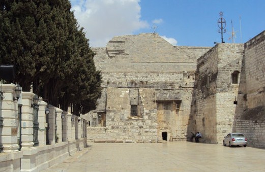
Bethlehem (Arabic: بيت لحم, Beit Lahm, Hebrew: בית לחם Beit Lechem) is a small city located some 10 km (6 miles) south of the Old City of Jerusalem within the West Bank, in an "Area A" zone administered by the Palestinian Authority.
Ariel (Hebrew: אריאל) is an Israeli settlement in "Area C" (Israeli-managed territory in the West Bank), within the north-central West Bank (Judea and Samaria). It is approximately 40 km east of Tel-Aviv and 30 km east of Petah Tikva.
Shiloh a small Israeli settlement in the north-central West Bank, located near the historical site of the Samarian city of the same name.

Maale Adumim is an Israeli settlement in the West Bank, east of Jerusalem. It has about 37,000 residents.

Gush Etzion is a group of Israeli settlements in the West Bank between Bethlehem and Hebron, about 950 meters above the sea level. It has a rich history dating from the 1920s and 30s to recent times.

For the other part of the sea, see Dead Sea (Jordan). The Dead Sea (Hebrew: ים המלח, Hebrew transliteration:Yam HaMelach; Arabic: البحر الميت, Arabic transliteration: al-Bahir al-Mayyit) has its western coast in Israel and the West Bank.
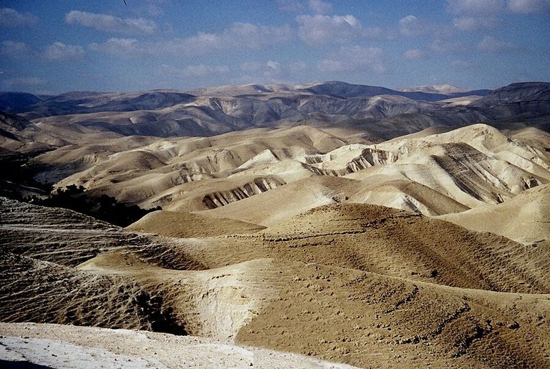
The Judaean Desert is a desert in Israel and the West Bank that lies east of Jerusalem and the Judean hills and west of the Jordan Valley and Dead Sea.
Articles and travel topics about West Bank and Palestine.
 Itineraries
The Rideau Canal is a historical scenic waterway that connects the towns of Kingston and Ottawa in Ontario, Canada. It has been declared a UNESCO World Heritage Site.
Wikivoyage
 Itineraries
The Rheinburgenweg (Rhine Castles Trail) is a 200 km (120 mi) hiking trail in the Middle Rhine Valley region of Germany.
Wikivoyage
 Culture & history
The British Empire was, at its peak, the largest empire in history; it controlled just short of a quarter of the world's land area and a quarter of the population.
Wikivoyage
 Culture & history
Judaism is one of the monotheistic religions, sharing a common origin with the world's two most prolific religions, Christianity and Islam.
Wikivoyage
Every section of the guide. Open one to read it in full.